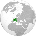
File:Frankish Empire (orthographic projection).svg
Appearance

Size of this PNG preview of this SVG file: 551 × 550 pixels. Other resolutions: 240 × 240 pixels | 481 × 480 pixels | 769 × 768 pixels | 1,026 × 1,024 pixels | 2,052 × 2,048 pixels.
Original file (SVG file, nominally 551 × 550 pixels, file size: 735 KB)
File history
Click on a date/time to view the file as it appeared at that time.
| Date/Time | Thumbnail | Dimensions | User | Comment | |
|---|---|---|---|---|---|
| current | 12:15, 2 December 2009 |  | 551 × 550 (735 KB) | KarnRedsun | The present political lines above the location of empire. |
| 11:46, 25 September 2009 |  | 550 × 550 (728 KB) | KarnRedsun | {{Information |Description={{en|1=Maps of Frankish Empire with orthographic projection}} |Source=Own work by uploader |Author=KarnRedsun |Date=2009-09-25 |Permission= |other_versions= }} Category:Maps of the Frankish territory [[C |
File usage
There are no pages that use this file.
Global file usage
The following other wikis use this file:
- Usage on ast.wikipedia.org
- Usage on azb.wikipedia.org
- Usage on bg.wikipedia.org
- Usage on el.wikipedia.org
- Usage on gl.wikipedia.org
- Usage on ja.wikipedia.org
- Usage on ja.wikivoyage.org
- Usage on lv.wikipedia.org
- Usage on pl.wikipedia.org
- Usage on ru.wikipedia.org
- Usage on simple.wikipedia.org
- Usage on vi.wikipedia.org
- Usage on www.wikidata.org

